Delaware Seeks Data on Climate Change’s Impact on Insurance

Participating in National Insurer Climate Risk Disclosure Survey

Insurance Commissioner Trinidad Navarro has announced Delaware’s participation in the National Association of Insurance Commissioners’ Insurer Climate Risk Disclosure Survey, an effort to assess how the impacts of climate change will reverberate across the insurance industry. From investment practices, to increased claim occurrences impacting companies’ financial sturdiness, to insurance product accessibility for consumers, the changing environment means that insurance must be a changing industry.

Insurance departments throughout the United States are working to evaluate both risks to the industry, and its resiliency in responding to those challenges to ensure continued market stability through several mechanisms, including National Association of Insurance Commissioners’ (NAIC) Climate and Resiliency Task Force and the eight-section survey.

“In Delaware and across the country, residents are feeling the impacts of climate change, and relying on insurers to respond to the heightened risk of damage to our properties, businesses, homes, and lives. As natural disasters occur more frequently and with more intensity, the industry must be prepared to provide rapid response,” said Insurance Commissioner Trinidad Navarro. “The issues of affordability and access seen as a result of wildfires in the west and hurricanes in the south have served as ominous forewarnings of what may be to come in our own region, and through participating in the Climate Risk Disclosure Survey we can better understand how prepared Delaware insurers are for these events and what opportunities we have to protect residents from these effects.”

Eighty-two Delaware insurers that reported $100 million or more in 2020 premiums have been asked to respond to questions about their investment and risk management policies, processes to identify, assess, and reduce climate-related risks, actions taken to encourage policyholder mitigation efforts and engage key constituencies in climate-based discussions, as well as information about the company’s existing analysis of risk and their organization’s climate-related goals, such as reducing emissions.

Surveys are due August 31, 2021. In total, over 1,200 insurers will complete the Survey, representing more than 70% of the U.S. insurance market. The California Department of Insurance, who asked Delaware to participate in this year’s Survey, will compile the data of all participating states and issue a public report.

Responding insurers with survey-related questions can contact Special Deputy Frank Pyle.
View the Insurer Climate Risk Disclosure Survey

View Survey Results for Prior Years


Important Insurance Reminders After Tropical Storm Isaias

Commissioner Navarro encourages caution in repairs, meets with community

Tropical Storm Isaias produced tornado activity, heavy rain and flooding, hail, and strong winds throughout the state, causing significant destruction in several Delaware communities. Insurance Commissioner Trinidad Navarro visited residents and assessed damage on Wednesday.

“While measuring the full extent of this storm will take time, we know one thing – we must come together as a community and support those that need to rebuild,” said Commissioner Navarro after touring Amberwood community in Bear, which saw extensive storm impacts, and speaking with those beginning the insurance claims process. “I understand the eagerness of every resident to clean up and make repairs, but I can’t emphasize enough the importance of contacting your insurance company first. Take photos of everything and do not make permanent repairs before working with your insurance adjuster. Make only necessary, temporary repairs to prevent additional damage. Save all documentation, pictures, and receipts.”

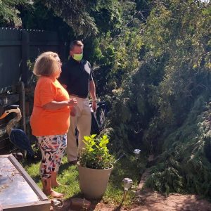
Insurance Commissioner Trinidad Navarro talks with a resident next to a down tree.

The Delaware Department of Insurance Consumer Services Division is working with residents who have questions or concerns about their insurance company’s actions, and can be reached at (800) 282-8611 or (302) 674-6227, or by email at consumer@delaware.gov.

Underscoring the importance of proceeding through the insurance claim and property repair process with caution, Commissioner Navarro highlighted the frequency of fraudulent activity after a storm: “Anytime we experience a big storm like Isaias, we see storm-chasing scammers pop up in neighborhoods, falsely stating they are with an insurance company, or encouraging homeowners to sign on to repair contracts without going through the proper channels – often price gouging residents, or completing shoddy repairs if they make any at all, leaving the consumer on the hook for costs that could have been covered by an insurer.”

Residents who encounter a storm-related insurance scam can contact the Fraud Prevention Bureau at (800) 632-5154 or (302) 674-7350, or email fraud@delaware.gov. Consumers are urged to carefully review contracts for home repairs, ask for references and research companies through the Better Business Bureau.

Consumers may contact the Delaware Emergency Management Agency, DEMA, to see what assistance may be available as a result of the Governor’s State of Emergency. Property insurance policyholders should be aware of the dwelling deductible stated on their insurance declaration page, and take note that there may be a deductible for named storms, wind, hail, or tornadoes that may apply to the claim, most often stated as a percentage of dwelling coverage.

Due to COVID-19 precautions, Department of Insurance offices are not currently open to the public, but residents are encouraged to contact the department at one of the emails or phone numbers above, or call (302) 674-7300 for assistance.

Insurance Commissioner Trinidad Navarro speaking to a resident whose deck was damaged by the storm.Insurance Commissioner Trinidad Navarro speaking to residents.


Navarro Urges Residents to Prepare for Tropical Storm Isaias

Provides information on insurance processes for property damage

As Tropical Storm Isaias approaches Delaware, residents are urged to prepare for dangerous winds over 55 miles per hour and up to 6 inches of rain. Storm surges, localized flooding, tree damage, power outages, and other threats to life and property are possible, according to the National Weather Service (NWS). Rain is expected Monday evening, with the brunt of the storm arriving early on Tuesday.

“As models continue to show Delaware in the path of this storm, home and business owners should take steps to reduce property damage and stay safe,” said Insurance Commissioner Trinidad Navarro. “Secure any outdoor items or furniture that could cause damage when windy conditions occur, charge your cellphones, gather emergency supplies, and make a plan about where you can take shelter away from windows at the peak of the storm. Keep in mind that roads may become difficult to navigate due to debris and tree damage, and never drive through a flooded area.”

Isaias is expected to hit Delaware Tuesday morning. Potential storm impacts include damage to porches, carports and other awnings, as well as roofing and siding, with impacts on mobile homes more significant. NWS expects uprooted or snapped trees in addition to flooding, causing impassable roadways and power outages in some places. Storm surges are likely, and tornadoes are possible.

In advance of storms, residents are urged to locate important documents, including homeowners and auto insurance policies and company contact information, as well as a complete a home inventory. If your property is damaged by Tropical Storm Isaias, contact your insurer before you clean up or make repairs, and photograph all damage. After speaking with your insurer and photographing damage, take action to prevent further damage by covering broken windows, damaged walls, or leaking roofs, but do not make permanent repairs. Your insurance company should inspect the property and estimate the cost of permanent repairs. Save all receipts and documentation, including those related to temporary repairs.

Hurricane season lasts well into the fall, and residents should make plans and take precautions now to reduce future risks, including exploring flood insurance. More than 20 percent of flood insurance claims are for properties outside of high-risk areas. Flood insurance policies typically take 30 days to go into effect. For more information about FEMA’s flood insurance program and to find an agent in your area, visit FloodSmart.gov or call 1-800-427-4661.

For more information on how to prepare your home for inclement weather, visit the Department of Insurance Disaster Preparedness page.


Preliminary Flood Insurance Rate Maps appeal period runs to Sept. 1 for parts of Kent and Sussex County

DOVER – DNREC’s Division of Watershed Stewardship reminds residents of Kent and Sussex County that preliminary Flood Insurance Rate Maps for portions of the two counties released last year by the Federal Emergency Management Agency (FEMA) are currently in a 90-day regulatory appeal period that ends Sept. 1.

Anyone who believes that the preliminary maps (found online at www.de.gov/floodplanning) may contain errors can submit an appeal to their community floodplain administrator. The floodplain administrator will review and consolidate all appeals before forwarding them to FEMA. Once FEMA has reviewed appeals and made a determination on their validity, the agency will issue a Letter of Final Determination to the communities. The preliminary maps will become effective six months after the Letter of Final Determination, currently projected to be June 15, 2018.

FEMA’s National Flood Insurance Program makes flood insurance available to local property owners. Mortgage lenders require borrowers whose properties are located in a designated special flood hazard area to purchase flood insurance as a condition of receiving a federally backed mortgage loan in accordance with the Federal Disaster Protection Act of 1973. FEMA’s flood risk maps are used by insurance companies to establish insurance rates and by local communities to enforce local floodplain codes.

“Hydrologic studies that determine water flows, base flood elevations and accurate floodplain boundaries were performed by DNREC on about 200 miles of waterways in western Sussex and southwestern Kent Counties,” said Michael Powell, DNREC flood program manager. “With these results, base flood elevations for many areas are now shown on FEMA’s maps for the first time, providing property owners with more detailed and accurate flood risk assessments.”

For more information on the flood risk maps, contact Greg Williams or Michael Powell, Division of Watershed Stewardship, at 302-739-9921. For information on DNREC’s flood mitigation program, please visit DNREC’s website at http://www.dnrec.delaware.gov/swc/Drainage/Pages/Flooding.aspx.

Media contact: Michael Globetti, DNREC Public Affairs, 302-739-9902

Vol. 47, No. 151

-30-


DNREC, FEMA to sponsor open house May 23 in New Castle on preliminary flood risk maps for parts of New Castle County

DOVER – DNREC’s Division of Watershed Stewardship and the Federal Emergency Management Agency (FEMA) will hold an open house Tuesday, May 23 about new preliminary flood insurance rate maps for parts of New Castle County. The open house will be held at the William Penn High School at 713 E. Basin Road, New Castle, DE 19720 from 4 – 7 p.m. The public is encouraged to attend to learn more about proposed flood risk map changes and to understand better how proposed map changes affect their property.

A cooperating technical partnership between the Division of Watershed Stewardship and FEMA aims to improve the accuracy of flood risk maps statewide. New preliminary flood risk maps for portions of New Castle County were released in December 2016. To get data for the preliminary flood risk maps, DNREC did hydrologic studies that determine water flows during flood events, base flood elevations and more accurate floodplain boundaries using newer elevation contours on about 150 miles of streams in New Castle County. The results enabled FEMA’s maps to show base flood elevations for many areas for the first time, providing property owners with more detailed and accurate flood risk assessments.

FEMA’s flood risk maps are used by insurance companies to establish insurance rates and by local communities to enforce local floodplain codes. Many communities have recently amended local codes to adopt higher floodplain development standards, in conjunction with the release of the new flood risk maps. Many of these higher standards – such as first-floor freeboard (building living space to a margin of safety above predicted flood levels), limiting development in floodplains, and flood resistant foundation designs – were recommended by the Floodplain and Drainage Advisory Committee formed as a result of Delaware Senate Bill 64 passed in 2011 to support more effective floodplain management standards.

FEMA’s National Flood Insurance Program makes flood insurance available to local property owners. Mortgage lenders require borrowers whose properties are located in a designated special flood hazard area to purchase flood insurance as a condition of receiving a federally-backed mortgage loan in accordance with the Federal Disaster Protection Act of 1973. Standard homeowners insurance does not cover damage caused by flooding, but all property owners and renters can purchase flood insurance. Homeowners interested in how the proposed changes could impact the cost of their flood insurance premium should contact their insurance agent.

Preliminary flood risk maps, as well as current maps, can be viewed at www.de.gov/floodplanning. For more information on flood risk maps, please contact Greg Williams or Michael Powell, Division of Watershed Stewardship, 302-739-9921. For information on the DNREC’s flood mitigation program, visit DNREC’s website at http://www.dnrec.delaware.gov/swc/Drainage/Pages/Flooding.aspx.

Media contact: Michael Globetti, DNREC Public Affairs 302-739-9902

Vol. 47, No. 104

-30-