


Delaware Emergency Management Agency Monitoring Joaquin
Delaware Emergency Management Agency | Kent County | New Castle County | Sussex County | Date Posted: Wednesday, September 30, 2015

 Attorney General Jennings announces two major victories striking down executive orders on elections
 Delaware’s 153rd General Assembly Advances DHSS Priorities to Lower Costs, Strengthen Care Workforce
 Gov. Meyer Signs FY2027 Budget Investing in Education, Affordability, and Opportunity
 Delaware students earn national STEM recognition through Career and Technical Education
 Delaware students earn national recognition while building the future of healthcare
 Delaware on Main Street Program Grows as 17 Communities Earn National Designations
 Gov. Meyer Calls Upon Delaware Public Service Commission to Suspend Delmarva Rate Hike
 DSHA, American Heart Association to provide blood pressure monitoring devices in public housing communities
 Dozens of Incarcerated Students Earn High School Diplomas as Academic Year Closes DOJ secures 59-year sentence for Wilmington man who caused fatal collision that claimed two lives, injured four others DOJ announces sentence for final Exit 4 member associated with four-year crime spree
 National Grant Initiative Invests in Delaware’s Indigenous and Cuban Cultural Traditions
 Delaware and Wilmington Named Among Nation’s Most Arts-Vibrant by SMU DataArts
 DNREC Asks Public to Report Sightings of Wild Turkeys During Annual Survey
 Office of Women’s Advancement & Advocacy & Delaware Women’s Commission Announce 2026 She’s on Her Way Award Recipients DOJ indicts suspected Wilmington Hospital shooter on multiple felony charges
 Military Families Can Visit Select Museums for Free this Summer as part of Blue Star Museums
 Delaware State Parks Kicks Off Virtual 5K Fundraiser to Celebrate 75th Anniversary
 Visit Delaware and 1440 Film Co. Win Telly Award for “Back of House” Video Series
 ADVISORY: State Leaders to Host Press Conference Launching Legislative Hall Period Product Drive
 Delaware SUN Bucks Available in June to Help Families Feed Children this Summer
 DNREC Offers Expanded Assistance for Farmers Due to Significantly Increased Reports of Deer Damage AG Jennings secures final victory over Trump Administration’s ban on offshore wind permitting Governor Meyer Calls for Immediate Action to Protect Delaware Ratepayers and Hold Utilities Accountable
 Governor Meyer and DSHA Announce Major Step Forward for Hope Center Expansion in Kent County
 DNREC Indian River Dredging Project Near Millsboro to Improve Boater Navigation, Restore Tidal Wetlands
 Delaware Brownfield Conference, Hosted by DNREC, to be Held Aug. 20 in Wilmington AG Jennings defeats Koch billionaire-backed effort to upend Delaware’s election transparency laws DOJ secures multiple convictions including Murder First in fatal Newark pedestrian collision DOJ indicts suspended Delmar officer on multiple counts of Official Misconduct, Unlawful Sexual Contact
 Gabriel Alfaro Reels in 10.1 Pounds of Fish to Win 40th Annual Delaware Youth Fishing Tournament
 Delaware Department of Human Resources Hosts Third Statewide Career Fair of 2026
 Delaware Public Archives Kicks Off Summer Spotlighting Delaware Beach Memories in New Digital Exhibit
 Delaware Division of the Arts Earns 20 Awards at 2026 Delaware Press Association Communications Contest
 Delaware’s Largest Class of 27 Individual Artist Fellows Headlines “Award Winners XXVI” DOJ secures major prison time for three Exit 4 members involved in the murder of Carrie Mondell and Khalil Ameer-Bey
 State and Thomas Jefferson University Partner to Establish Delaware’s First Medical School
 Delaware Leaders Respond to Third Circuit’s Order that the State Comply with Immigration Subpoena
 Disaster Housing Recovery and Resiliency Planning Workshops for Delaware Municipalities DOJ secures convictions for two Exit 4 gang members in the murder of Latahesia Hill and Carrie Mondell Statement from AG Jennings on Trump’s payout to January 6th insurrectionists
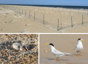 Delaware Takes New Approach to Improve Breeding Success for Endangered Beach-Nesting Least Terns
 Spring Stopover Puts Delaware at Center of Annual Shorebird Migration Phenomenon
 Department of Elections Announces Primary Election Party Change Deadline, Friday, May 29, 2026, 11:59 pm
Delaware Emergency Management Agency | Kent County | New Castle County | Sussex County | Date Posted: Wednesday, September 30, 2015
Smyrna – The Delaware Emergency Management Agency (DEMA) is monitoring Hurricane Joaquin, and is in communication with its partners at the National Weather Service, and the National Hurricane Center.
The forecast track for Joaquin is uncertain at this time, but it is reasonably sure that the tropical system will have an impact of some kind on Delaware over the weekend. It is too early to tell exactly what that impact will be.
Here is the latest from the National Weather Service in Mount Holly, NJ…
“A dangerous weather pattern is developing for our region. Threats include very heavy rainfall, inland river flooding, as well as major coastal flooding with heavy surf and beach erosion. These impacts will be felt this week from a storm system affecting the region. There is now also the potential for major impacts from Hurricane Joaquin affecting the region this weekend into early next week.”
“Many locations saw one to two inches from last night’s rainfall. Additional rainfall amounts over the next seven days of 4 to 10 inches are possible for the region, with some locations seeing locally higher amounts.”
“Additional rainfall amounts of 4 to 10 inches will result in a greatly increased threat of flash flooding as well as inland river flooding. If we get the higher rainfall amounts, some of the flooding will be severe.”
“Starting Thursday, winds will become northeast and intensify. Wind gusts of 20 to 30 mph are possible over inland locations. Wind gusts of 45+ mph are possible in coastal areas. If Hurricane Joaquin directly affects the region, hurricane force winds are possible.”
“Moderate coastal flooding is possible on Thursday. Moderate to major coastal flooding is now possible on Friday with the strong northeast winds. This is in advance of any impacts from Hurricane Joaquin. If Hurricane Joaquin directly affects the region, major to record coastal flooding is possible.”
“Heavy rainfall will impact the region again Thursday night into Friday, along with the risk of inland river flooding and major coastal flooding. The most likely timeframe for impacts from Hurricane Joaquin affecting the region is Sunday into Monday.
Never…never ever drive into flooded roadways. Take action now to mitigate the effects of flooding…check storm drains and sewer grates along curbs near your property to assure that they are clear of leaves debris that could cause backups and flooding.
While it is not raining, check rain gutters and spouts on your home to make sure they are cleared of leaves and small branches.
High winds are also on the way so make sure that loose items in the yard are secured.
Check and update your Home Emergency Kit. It’s a good idea to have a radio capable of receiving NOAA forecasts.
For tips on how to prepare, log on to ready.gov.
DEMA will send updates as they become available.
Keep up to date by receiving a daily digest email, around noon, of current news release posts from state agencies on news.delaware.gov.
Here you can subscribe to future news updates.
Delaware's Governor
State Agencies
Elected Officials
General Assembly
Delaware Courts
State Employees
Cities & Towns
Delaware State Code
State Regulations
Business First Steps
Phone Directory
Locations Directory
Public Meetings
Voting & Elections
Transparency
Delaware Marketplace
Tax Center
Personal Income Tax
Privacy Policy
Weather & Travel
Contact Us
Corporations
Franchise Tax
Gross Receipts Tax
Withholding Tax
Delaware Topics
Help Center
Mobile Apps
E-mail / Text Alerts
Social Media

Built by the Government Information Center
©MMXXVI Delaware.gov
