


Delaware Launches School Security Initiative
Delaware Emergency Management Agency | Department of Safety and Homeland Security | Newsroom | Date Posted: Monday, October 17, 2022

 AG Jennings announces multistate settlement of bankruptcy claims against 23andMe over genetic data breach
 Governor Meyer Launches Delaware Commercial Corridor Initiative To Support Small Businesses
 Governor Meyer Orders the Lowering of Flags in Concurrence with White House
 Delaware Office of Highway Safety Sober Rides Program Helped More Than 900 Delawareans Get Home Safely
 Governor Meyer’s Statement on Traffic Stop in Dover, Pledges Full Investigation
 Talk & Film Bring Delaware’s Revolutionary Story to Life at Archives’ First Saturday Program Governor Meyer Vetoes $35 Million Legislative Hall Expansion Amid Affordability Concerns
 Delaware Hospitals Adopt Statewide Emergency Department Guidance for Opioid Use Disorder Treatment
 Gov. Meyer Signs Banking Modernization Package to Strengthen Delaware’s Leadership in Financial Services
 Newly Launched Initiative Strengthens Delaware’s Health Information Technology Infrastructure Attorney General Jennings announces two major victories striking down executive orders on elections
 Delaware’s 153rd General Assembly Advances DHSS Priorities to Lower Costs, Strengthen Care Workforce Gov. Meyer Signs FY2027 Budget Investing in Education, Affordability, and Opportunity
 Delaware students earn national STEM recognition through Career and Technical Education
 Delaware students earn national recognition while building the future of healthcare
 Delaware on Main Street Program Grows as 17 Communities Earn National Designations Gov. Meyer Calls Upon Delaware Public Service Commission to Suspend Delmarva Rate Hike
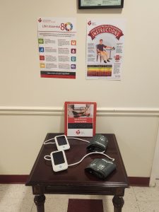 DSHA, American Heart Association to provide blood pressure monitoring devices in public housing communities
 Dozens of Incarcerated Students Earn High School Diplomas as Academic Year Closes DOJ secures 59-year sentence for Wilmington man who caused fatal collision that claimed two lives, injured four others DOJ announces sentence for final Exit 4 member associated with four-year crime spree
 National Grant Initiative Invests in Delaware’s Indigenous and Cuban Cultural Traditions
 Delaware and Wilmington Named Among Nation’s Most Arts-Vibrant by SMU DataArts
 DNREC Asks Public to Report Sightings of Wild Turkeys During Annual Survey
 Office of Women’s Advancement & Advocacy & Delaware Women’s Commission Announce 2026 She’s on Her Way Award Recipients DOJ indicts suspected Wilmington Hospital shooter on multiple felony charges
 Military Families Can Visit Select Museums for Free this Summer as part of Blue Star Museums
 Delaware State Parks Kicks Off Virtual 5K Fundraiser to Celebrate 75th Anniversary
 Visit Delaware and 1440 Film Co. Win Telly Award for “Back of House” Video Series
 ADVISORY: State Leaders to Host Press Conference Launching Legislative Hall Period Product Drive
 Delaware SUN Bucks Available in June to Help Families Feed Children this Summer
 DNREC Offers Expanded Assistance for Farmers Due to Significantly Increased Reports of Deer Damage AG Jennings secures final victory over Trump Administration’s ban on offshore wind permitting Governor Meyer Calls for Immediate Action to Protect Delaware Ratepayers and Hold Utilities Accountable
 Governor Meyer and DSHA Announce Major Step Forward for Hope Center Expansion in Kent County
 DNREC Indian River Dredging Project Near Millsboro to Improve Boater Navigation, Restore Tidal Wetlands
 Delaware Brownfield Conference, Hosted by DNREC, to be Held Aug. 20 in Wilmington AG Jennings defeats Koch billionaire-backed effort to upend Delaware’s election transparency laws DOJ secures multiple convictions including Murder First in fatal Newark pedestrian collision DOJ indicts suspended Delmar officer on multiple counts of Official Misconduct, Unlawful Sexual Contact
 Gabriel Alfaro Reels in 10.1 Pounds of Fish to Win 40th Annual Delaware Youth Fishing Tournament
 Delaware Department of Human Resources Hosts Third Statewide Career Fair of 2026
 Delaware Public Archives Kicks Off Summer Spotlighting Delaware Beach Memories in New Digital Exhibit
 Delaware Division of the Arts Earns 20 Awards at 2026 Delaware Press Association Communications Contest
 Delaware’s Largest Class of 27 Individual Artist Fellows Headlines “Award Winners XXVI” DOJ secures major prison time for three Exit 4 members involved in the murder of Carrie Mondell and Khalil Ameer-Bey
 State and Thomas Jefferson University Partner to Establish Delaware’s First Medical School
Delaware Emergency Management Agency | Department of Safety and Homeland Security | Newsroom | Date Posted: Monday, October 17, 2022


SMYRNA, Del. (October 17, 2022) — The Delaware Emergency Management Agency (DEMA) and its Comprehensive School Safety Program will invest almost $1 million to enhance school security statewide by providing accurate and uniform maps for all of Delaware’s 19 public school districts and charter schools to enable law enforcement and first responders to react swiftly during emergencies in unfamiliar environments. Delaware’s General Assembly provided the funding this year as part of a $10 million allocation to the School Safety and Security Fund, which was originally established in 2018. Under the bill, $1 million was provided to the Department of Safety and Homeland Security for “school mapping, reporting application, and threat assessment tools.”
“These digital blueprints and maps represent a significant, tangible investment in school safety and security throughout Delaware. The goal is to ensure all emergency personnel have the best tools to communicate and collaborate in a crisis – when seconds count and lives are on the line,” said Safety and Homeland Security Secretary Nathaniel McQueen, Jr.
Delaware is partnering with Critical Response Group, a New Jersey-based firm that specializes in collecting and digitizing school building blueprints and making them available to first responders. Its proprietary Collaborative Response Graphics® (CRGs) are built upon the same tactical and operational framework used by highly trained military units. Featuring a gridded overlay map of school buildings and grounds, CRGs provide simple visual communication tools to coordinate emergency response during an incident. Easily understood during stressful situations, the maps enhance response time and improve command and control during an incident. Any changes will be updated continuously in a sharable and easily accessible format for ready access by school officials, emergency personnel, and law enforcement.
The maps combine detailed information on floor plans – including room labels, hallway names, external door/stairwell numbers, and key utility locations – with high-resolution imagery of the entire campus and accurate labeling for parking areas, athletic fields, roads, and neighboring properties. The goal is to give first responders everything they need to coordinate emergency response both inside and outside the building.
Copies of each high-resolution composite map will be available to local, county, and state emergency operations and dispatch centers, law enforcement personnel, and on-scene first responders. They will also be utilized to facilitate interagency training exercises, school drills, and coordinate any post-emergency reunification process. Once complete, cooperating agencies plan to conduct periodic walk-throughs and campus visits to ensure that each of the maps is current and up to date.
Video Overview of Critical Response Group Maps: https://www.youtube.com/watch?v=10aghbY3AKI&t=30s
###
Keep up to date by receiving a daily digest email, around noon, of current news release posts from state agencies on news.delaware.gov.
Here you can subscribe to future news updates.
Delaware Emergency Management Agency | Department of Safety and Homeland Security | Newsroom | Date Posted: Monday, October 17, 2022
SMYRNA, Del. (October 17, 2022) — The Delaware Emergency Management Agency (DEMA) and its Comprehensive School Safety Program will invest almost $1 million to enhance school security statewide by providing accurate and uniform maps for all of Delaware’s 19 public school districts and charter schools to enable law enforcement and first responders to react swiftly during emergencies in unfamiliar environments. Delaware’s General Assembly provided the funding this year as part of a $10 million allocation to the School Safety and Security Fund, which was originally established in 2018. Under the bill, $1 million was provided to the Department of Safety and Homeland Security for “school mapping, reporting application, and threat assessment tools.”
“These digital blueprints and maps represent a significant, tangible investment in school safety and security throughout Delaware. The goal is to ensure all emergency personnel have the best tools to communicate and collaborate in a crisis – when seconds count and lives are on the line,” said Safety and Homeland Security Secretary Nathaniel McQueen, Jr.
Delaware is partnering with Critical Response Group, a New Jersey-based firm that specializes in collecting and digitizing school building blueprints and making them available to first responders. Its proprietary Collaborative Response Graphics® (CRGs) are built upon the same tactical and operational framework used by highly trained military units. Featuring a gridded overlay map of school buildings and grounds, CRGs provide simple visual communication tools to coordinate emergency response during an incident. Easily understood during stressful situations, the maps enhance response time and improve command and control during an incident. Any changes will be updated continuously in a sharable and easily accessible format for ready access by school officials, emergency personnel, and law enforcement.
The maps combine detailed information on floor plans – including room labels, hallway names, external door/stairwell numbers, and key utility locations – with high-resolution imagery of the entire campus and accurate labeling for parking areas, athletic fields, roads, and neighboring properties. The goal is to give first responders everything they need to coordinate emergency response both inside and outside the building.
Copies of each high-resolution composite map will be available to local, county, and state emergency operations and dispatch centers, law enforcement personnel, and on-scene first responders. They will also be utilized to facilitate interagency training exercises, school drills, and coordinate any post-emergency reunification process. Once complete, cooperating agencies plan to conduct periodic walk-throughs and campus visits to ensure that each of the maps is current and up to date.
Video Overview of Critical Response Group Maps: https://www.youtube.com/watch?v=10aghbY3AKI&t=30s
###
Keep up to date by receiving a daily digest email, around noon, of current news release posts from state agencies on news.delaware.gov.
Here you can subscribe to future news updates.
Delaware's Governor
State Agencies
Elected Officials
General Assembly
Delaware Courts
State Employees
Cities & Towns
Delaware State Code
State Regulations
Business First Steps
Phone Directory
Locations Directory
Public Meetings
Voting & Elections
Transparency
Delaware Marketplace
Tax Center
Personal Income Tax
Privacy Policy
Weather & Travel
Contact Us
Corporations
Franchise Tax
Gross Receipts Tax
Withholding Tax
Delaware Topics
Help Center
Mobile Apps
E-mail / Text Alerts
Social Media

Built by the Government Information Center
©MMXXVI Delaware.gov
