


Storm Report #3 Saturday, January 23, 2016 (5:30am)
Delaware Emergency Management Agency | Date Posted: Saturday, January 23, 2016

 Dozens of Incarcerated Students Earn High School Diplomas as Academic Year Closes
 DOJ secures 59-year sentence for Wilmington man who caused fatal collision that claimed two lives, injured four others DOJ announces sentence for final Exit 4 member associated with four-year crime spree
 National Grant Initiative Invests in Delaware’s Indigenous and Cuban Cultural Traditions
 Delaware and Wilmington Named Among Nation’s Most Arts-Vibrant by SMU DataArts
 DNREC Asks Public to Report Sightings of Wild Turkeys During Annual Survey
 Office of Women’s Advancement & Advocacy & Delaware Women’s Commission Announce 2026 She’s on Her Way Award Recipients DOJ indicts suspected Wilmington Hospital shooter on multiple felony charges
 Military Families Can Visit Select Museums for Free this Summer as part of Blue Star Museums
 Delaware State Parks Kicks Off Virtual 5K Fundraiser to Celebrate 75th Anniversary
 Visit Delaware and 1440 Film Co. Win Telly Award for “Back of House” Video Series
 ADVISORY: State Leaders to Host Press Conference Launching Legislative Hall Period Product Drive
 Delaware SUN Bucks Available in June to Help Families Feed Children this Summer
 DNREC Offers Expanded Assistance for Farmers Due to Significantly Increased Reports of Deer Damage AG Jennings secures final victory over Trump Administration’s ban on offshore wind permitting
 Governor Meyer Calls for Immediate Action to Protect Delaware Ratepayers and Hold Utilities Accountable
 Governor Meyer and DSHA Announce Major Step Forward for Hope Center Expansion in Kent County
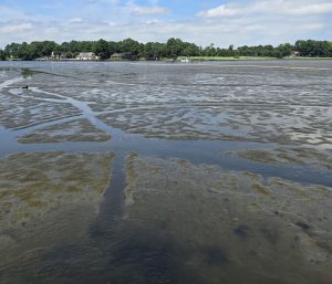 DNREC Indian River Dredging Project Near Millsboro to Improve Boater Navigation, Restore Tidal Wetlands
 Delaware Brownfield Conference, Hosted by DNREC, to be Held Aug. 20 in Wilmington AG Jennings defeats Koch billionaire-backed effort to upend Delaware’s election transparency laws DOJ secures multiple convictions including Murder First in fatal Newark pedestrian collision DOJ indicts suspended Delmar officer on multiple counts of Official Misconduct, Unlawful Sexual Contact
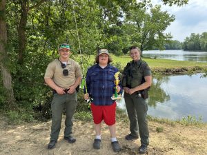 Gabriel Alfaro Reels in 10.1 Pounds of Fish to Win 40th Annual Delaware Youth Fishing Tournament
 Delaware Department of Human Resources Hosts Third Statewide Career Fair of 2026
 Delaware Public Archives Kicks Off Summer Spotlighting Delaware Beach Memories in New Digital Exhibit
 Delaware Division of the Arts Earns 20 Awards at 2026 Delaware Press Association Communications Contest
 Delaware’s Largest Class of 27 Individual Artist Fellows Headlines “Award Winners XXVI” DOJ secures major prison time for three Exit 4 members involved in the murder of Carrie Mondell and Khalil Ameer-Bey
 State and Thomas Jefferson University Partner to Establish Delaware’s First Medical School
 Delaware Leaders Respond to Third Circuit’s Order that the State Comply with Immigration Subpoena
 Disaster Housing Recovery and Resiliency Planning Workshops for Delaware Municipalities DOJ secures convictions for two Exit 4 gang members in the murder of Latahesia Hill and Carrie Mondell Statement from AG Jennings on Trump’s payout to January 6th insurrectionists
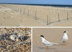 Delaware Takes New Approach to Improve Breeding Success for Endangered Beach-Nesting Least Terns
 Spring Stopover Puts Delaware at Center of Annual Shorebird Migration Phenomenon
 Department of Elections Announces Primary Election Party Change Deadline, Friday, May 29, 2026, 11:59 pm
 Delaware Revises Recreational Regs for Bluefish to Give Anglers Higher Daily Possession Limit
 Governor Meyer Congratulates Public Service Commissioners Following Confirmation
 Governor Meyer Orders the Lowering of Flags to Honor the Life of Mike Purzycki
 Drive Sober This Memorial Day Weekend: OHS, Law Enforcement Agencies Announce DUI Checkpoint
 Governor’s Volunteer Service Awards to Honor 41 Delawareans for Outstanding Service
 DNREC Expects to Complete Channel Marking Projects for Major Boating Waters Ahead of Memorial Day Weekend
 Woodbridge school counselor named 2026 Delaware Behavioral Health Professional of Year
 New DOC publication provides a look inside rehabilitative programs that drive reentry success
 DNREC Communications Team Earns Multiple First-Place Awards from Delaware Press Association
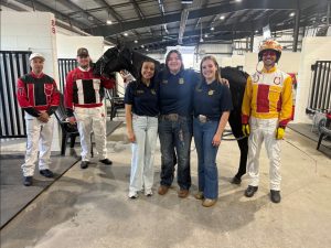 Delaware FFA students get inside look at harness racing industry at Harrington Raceway
 DelDOT Secretary Hastings Announces Lilia Montoya as New Chief Executive Officer
 Required Reservations for Five Most Popular Drive-on Surf Fishing Beaches Begin May 23
 Governor Meyer and DSB Announce Winners of Spring 2026 EDGE 2.0 Grant Competition
Delaware Emergency Management Agency | Date Posted: Saturday, January 23, 2016
(Smyrna) – Delaware continues under the State of Emergency declared yesterday by Governor Jack Markell. Level 1 driving restrictions went into effect at midnight, meaning that all persons operating a motor vehicle shall exercise extra caution in the operation of their motor vehicle. Non-essential personnel, regardless of whether employed by a public or private entity, are encouraged not to operate a motor vehicle on public roadways when a Level 1 Driving Warning has been activated, unless there is a significant health, safety or business necessity reason for doing so.
The Blizzard Warning is now in effect for New Castle and Kent Counties until 6:00am Sunday. Total accumulations of 18-24 inches of snow are expected in New Castle County, while Kent County is also forecast to receive 18-24 inches of snow, with 12-18 inches near the shore. A Winter Weather Warning is now in effect until 6am Sunday for Sussex County with an expected accumulation of 12-18 inches inland, and 8-12 inches along the coast. Snow will continue heavy at times throughout the day on Saturday in New Castle County before tapering off tonight and early Sunday morning. Kent and Sussex Counties should see heavy snow at times today, before changing over to periods of sleet and some rain, then quickly change back to all snow before tapering off Sunday morning.
A Coastal Flood Warning is in effect until noon Sunday, for Kent and Sussex Counties. Widespread major coastal flooding is expected, while major flooding is likely in some areas, especially Sussex County. The coastal flooding will last for three consecutive high tide cycles, pushing water up against the coast and into back bays and estuaries.
High tide on the Delaware oceanfront will occur between 6:30 and 7:30am Saturday morning, between 7:00 and 8:00pm Saturday evening, and between 7:00 and 8:00am Sunday morning. High tide on back bays and the Delaware Bay will occur later than along the ocean. Wave heights in near-shore waters over the weekend are forecast to build as high as 18 to 23 feet, with wave heights on the Delaware Bay as high as 4 to 8 feet. Some roadway flooding is expected, along with moderate property damage, and significant beach erosion. People living in flood-prone areas should be prepared for rising water levels and to take appropriate action to protect lives and property.
Roadways across the state are snow covered. DelDOT trucks are plowing and laying salt on major roads, bridges and toll plazas. Residents can track the progress of DelDOT plows by watching the snowplow tracker, available at deldot.gov, or on the DelDOT app on a smart phone.
The speed limit on I495 has been reduced to 45 MPH. Traffic accidents have been reported statewide, mostly property damage, and there are reports of a few disabled vehicles. Drifting snow is beginning to be a problem in some areas, with a few roads in the Dagsboro and Millsboro areas reported to be impassable. Abandoned vehicles are making it difficult for plows to open an area of Gravel Hill Road south of Millsboro.
Delaware Transit Corporation fixed route and intercounty service is suspended Saturday, as is paratransit service. There will be no SEPTA Saturday service operating in Delaware. AMTRAK is running a modified schedule in the northeast, as the winter storm slams multiple states.
All public school activities in the state for the weekend, including sporting events, have been postponed.
No shelters have been opened at this time. The Delaware National Guard has pre-positioned personnel and vehicles throughout the state to provide assistance where needed.
There are a small number of power outages in Wilmington and Claymont. There are also power outages being reported in Sussex County in the Greenwood, Robinsonville, Dewey Beach, Dagsboro/Frankford, South Bethany, Long Neck, and Stockley areas. High winds and wet snow make the possibility of more downed electric and other utility lines a concern for the weekend.
Snowfall accumulations vary across the state, with the highest reported at 9.7 inches in Port Penn. Other high amounts include 8.5 inches at West Dover, 8.3 inches at Woodside, and 8.3 inches in New Castle, with the lowest at Lewes where gauges measured 2.4 inches of snow.
Other snow amounts: in New Castle County, 6.3 inches of snow are measured in Talleyville, 5.6 at Glasgow, 5.5 at Greenville, 5.3 at White Clay Creek, 5.2 at Hockessin and Smyrna, 5.1 in Newark, 4.8 at Prices Corner and Claymont and 4.3 at Blackbird. Kent County has 5.8 inches of snow in Dover, 4.7 in Frederica, and 4.2 in Harrington. Sussex County has 7.4 inches of snow in Laurel, 5.7 in Ellendale, 4.3 inches at Stockley 4.0 inches in Bridgeville and Selbyville, and 3.6 inches in Seaford.
Keep up to date by receiving a daily digest email, around noon, of current news release posts from state agencies on news.delaware.gov.
Here you can subscribe to future news updates.
Delaware's Governor
State Agencies
Elected Officials
General Assembly
Delaware Courts
State Employees
Cities & Towns
Delaware State Code
State Regulations
Business First Steps
Phone Directory
Locations Directory
Public Meetings
Voting & Elections
Transparency
Delaware Marketplace
Tax Center
Personal Income Tax
Privacy Policy
Weather & Travel
Contact Us
Corporations
Franchise Tax
Gross Receipts Tax
Withholding Tax
Delaware Topics
Help Center
Mobile Apps
E-mail / Text Alerts
Social Media

Built by the Government Information Center
©MMXXVI Delaware.gov
